Many organizations rely on location intelligence software to make informed strategic decisions that move their businesses forward.
The global location intelligence market was valued at $21.21 billion in 2024 and is projected to grow at a CAGR of 16.8% from 2025 to 2030, according to industry analysis by GrandViewResearch. As these numbers indicate, location intelligence is becoming increasingly vital for businesses, driven by the widespread use of smart devices and investments in IoT and network services.
In fact, new data from Precisely shows that there has been a 62% year-over-year increase in prioritizing spatial analytics and a 22% increase in data enrichment initiatives among businesses, indicating a growing recognition of location intelligence’s value.
According to Precedence Research data, the biggest power users of location intelligence tools are sales and marketing professionals, with 20.7% of the market share, who primarily use them to optimize their segmentation and get the best results from their targeting.
However, if we take a look at location intelligence users by vertical, the transportation and logistics segment emerged as the top revenue contributor, capturing a significant share of 19.4%. This alignment is hardly surprising, considering that location intelligence is extensively employed to enhance route optimization, monitor shipments, and bolster operational efficiency within the transportation and logistics sector.
Table of Contents
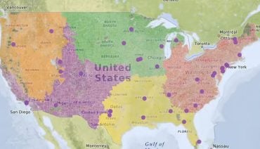
Location intelligence software, also called “spatial intelligence software,” is a business intelligence solution that provides location analytics to identify the relationship between certain objects based on their physical locations. You can also think of any software option as a map-based analytics platform for location data, data management, and related customer data.
Location intelligence tools enable users to visualize trends on maps and graphics to optimize certain business opportunities. Users can easily spot patterns and trends from these location analytics with the help of features like density analysis, distance and travel data, and geospatial mapping for determining terrain.
The use cases for location intelligence software are as varied as the industries using it:
Because location intelligence software often collects and processes personal information from website visitors, it must be used in a way that complies with applicable data privacy laws. This is achievable by adding a basic privacy policy to your website.
Businesses across a wide range of industries use location intelligence software to optimize operations and maximize revenue. However, the ideal location intelligence software for your business may be different than the perfect option for a business operating in a different industry. Here’s a look at your best location intelligence software options for 2025 and beyond, including notes on what software options work best for different use cases.
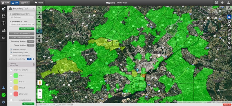
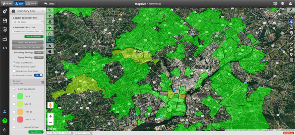
Maptive is the best all-around software for business data mapping. Its standout feature is its user-friendly interface, making it an ideal choice for both novice users and experienced professionals. Boasting advanced features and backed by a responsive customer service team, Maptive ensures a seamless experience. Plus, the platform’s continuous updates guarantee access to the latest in location intelligence capabilities, all without the need for any coding expertise.
It’s a great option for real estate firms, sales teams, healthcare businesses, transport and supply chain operations, plus more. Maptive offers a robust feature set that can support your team in analyzing spatial data, using predictive analytics to make business decisions, and so much more.
Maptive offers tools that can help any type of business, including drive time maps, heat maps, territory mapping tools, demographics, geographic boundary mapping, and data grouping, plus full customization of visualizations. Maptive will also soon launch CRM integrations so that you can connect the platform to your existing CRM.
The new version, Maptive IQ, introduces enhancements such as improved drive-time polygons, effortless territory management, and deeper demographic insights, further solidifying its position as a leader in the field. Maptive will also soon launch CRM integrations so that you can connect the platform to your existing CRM.
To learn more about Maptive’s mapping software and its business data mapping capabilities, schedule a demo. You can also start exploring Maptive through a free trial
Esri ArcGIS is a geographic information system (hence the GIS in the name) that offers unique capabilities and flexible licensing for applying location-based analytics to business practices. This location intelligence tool gives users insights via contextual tools to visualize and analyze data. Users can collaborate and share through maps, apps, dashboards, and reports.
For advanced GIS mapping, Esri ArcGIS is one of your best software options. Keep in mind that for more advanced tasks like automation, customization, or complex geoprocessing workflows, some level of coding knowledge can be beneficial. Esri offers scripting languages like Python and ArcGIS Arcade that can extend the functionality of ArcGIS. If you’re looking for location intelligence software that’s a little more well-rounded, you will want to explore others on this list.
Not all businesses need complex location intelligence software, some just need simple mapping capabilities, which makes tools like Scribble Maps very helpful.
Scribble Maps is an intuitive web-based mapping platform that enables users to create, customize, and share maps effortlessly. Designed for a broad audience—including hobbyists, students, professionals, and organizations—it offers a suite of features ranging from custom map creation to route optimization.
While it might not be the best option for companies that need location intelligence software on a daily basis, Scribble Maps is suited to users of all experience levels, including those without GIS expertise. It caters to a wide range of industries—such as real estate, education, logistics, and urban planning—offering customizable tools to meet specific business needs. With flexible pricing, including a free plan and premium options for advanced features, Scribble Maps provides a cost-effective solution for businesses and individuals looking for an accessible yet powerful mapping tool.
As such, Scribble Maps is a great option for organizations that need a stripped-down version of location intelligence tools that can provide general information and guidance.
Mapbox is a highly flexible and developer-friendly mapping platform that allows businesses to create fully customizable, interactive maps. With an open-source approach, Mapbox provides powerful APIs and SDKs for building dynamic, real-time mapping applications across web and mobile platforms.
Ideal for tech companies, app developers, and businesses that need highly customizable geolocation features, Mapbox enables advanced styling, 3D mapping, and real-time traffic data. It’s widely used in industries such as logistics, retail, and navigation-based applications.
While Mapbox offers powerful features, it does require some development knowledge to maximize its full potential.
Mapline is a user-friendly mapping tool designed for businesses looking to visualize location-based data quickly and efficiently. It’s an excellent option for small to mid-sized businesses that don’t require complex GIS functionalities but still want access to geographic insights.
With features like heat mapping, territory mapping, and data segmentation, Mapline allows users to analyze trends and make strategic decisions. It’s particularly useful for companies in sales, supply chain management, and market research. While it’s easy to use, businesses needing advanced analytics or AI-driven mapping solutions may find other tools on this list more suitable.
EasyMapMaker is an intuitive tool that helps users create maps from spreadsheet data with minimal effort. Businesses that need a fast way to plot locations, such as local businesses, non-profits, and event organizers, will find it valuable.
With no coding required, EasyMapMaker allows for bulk geocoding, clustering, and radius-based mapping, making it a solid option for companies with straightforward mapping needs.
However, if your business needs real-time data integration or predictive analytics, you’ll want to invest in more advanced mapping software.
BatchGeo is an excellent solution for organizations that rely heavily on spreadsheet data and need a quick way to visualize it on a map. It allows users to copy and paste location data directly from Excel or Google Sheets and instantly create interactive maps.
BatchGeo is simple to use and requires no technical knowledge–plus, is free tier allows users to make the most of a broad range of features. While great for basic mapping needs, its functionality is limited compared to more comprehensive GIS platforms.
eSpatial is a powerful location intelligence platform that specializes in sales territory mapping and analysis. It can help sales teams optimize their territories, track performance, and make data-driven decisions for better results.
With features like route optimization, demographic analysis, and heat maps, eSpatial is ideal for sales-driven organizations looking to improve efficiency. It integrates with popular CRMs like Salesforce, making it easy to incorporate into existing workflows.
While it excels in sales mapping, businesses needing deeper geospatial analysis, advanced cartography, or custom GIS modeling may want to explore other platforms with more comprehensive geographic data processing capabilities.
ZeeMaps is a web-based mapping tool that allows users to create interactive and collaborative maps. It’s particularly useful for businesses that need to share real-time location data with teams or customers.
ZeeMaps offers features such as live data integration, customizable markers, and map embedding for websites. It’s commonly used by media organizations, non-profits, and businesses that need a lightweight, collaborative mapping tool.
However, its analytics and predictive capabilities are more limited compared to higher-end location intelligence platforms. While ZeeMaps is great for real-time collaboration and basic mapping needs, it may not be the best fit for businesses that require advanced data visualization, spatial analysis, or AI-powered insights. Organizations needing deeper geospatial intelligence for market research, risk assessment, or large-scale logistics planning may find more comprehensive solutions elsewhere.
Geoblink is a location intelligence platform designed specifically for the retail and real estate industries, providing powerful insights into market trends, customer behavior, and site selection.
By leveraging geospatial analytics, demographic data, and predictive modeling, Geoblink helps businesses make data-driven decisions about store placements, target audience segmentation, and competitive positioning. Retailers can use it to optimize expansion strategies, identify high-performing locations, and enhance customer engagement, while real estate professionals can assess property demand, rental values, and foot traffic patterns.
With an intuitive interface and a strong focus on actionable insights, Geoblink is a valuable tool for businesses looking to stay ahead in highly competitive markets.
As we have established throughout this article, there’s no shortage of location intelligence software to consider when you need location-based insights for your business. The only question is: What features and functionalities do you need?
The best intelligence software for location data that fits your organization will be the one that helps streamline your work, create efficiencies within your business, and ultimately drive more revenue.
The booming location intelligence industry offers a golden opportunity for businesses to gain a competitive edge. By adopting these innovative tools early, companies can unlock valuable insights and optimize operations, putting them ahead of the curve.
If you’re interested in exploring Maptive as your location intelligence software of choice, get in touch with us to learn more or start your free trial.
Brad Crisp is the CEO at Maptive.com, based in Denver, CO and born in San Francisco, CA. He has extensive experience in Business Mapping, GIS, Data Visualization, Mapping Data Analytics and all forms of software development. His career includes Software Development and Venture Capital dating back to 1998 at businesses like Maptive, GlobalMojo (now Giving Assistant), KPG Ventures, Loopnet, NextCard, and Banking.