Today, we’re diving into the unsettling corners of Google Earth. Abandoned sites, cryptic messages, and unexplained phenomena await at these coordinates, promising to send shivers down your spine and leave you questioning what lurks beneath the pixelated surface.
Table of Contents
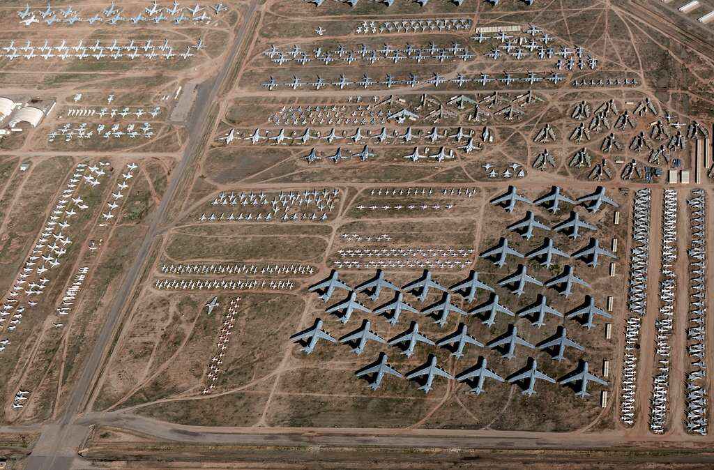
Coordinates: 32° 10′ 15.20″ N, 110° 51′ 18.66″ W
Deep in the Arizona desert lies a place nicknamed The Boneyard–a massive junkyard for airplanes and missiles. Officially known as the 309th Aerospace Maintenance and Regeneration Group (AMARG), it’s the world’s biggest storage facility for retired aircraft. Imagine nearly 4,000 planes from the US military and government agencies, all parked under the dry desert sun.
The dry air here is a lifesaver for these metal giants. Low humidity prevents rust, and the hard ground keeps them from sinking. AMARG’s story began in 1945, after World War II, when they needed a place to store all the leftover planes. Today, it houses everything from old bombers to jets, some even from other countries.
This isn’t a tourist destination though. It’s a high-security zone, but they do hold an annual run/walk event for the public if you ever get a chance to join.
The Boneyard has become famous beyond just storing planes. Movies like “Transformers: Revenge of the Fallen” filmed scenes here, and its spooky atmosphere has sparked ghost stories and legends, with some even saying the ghost of a pilot haunts the place.
With rows of retired aircraft stretching as far as the eye can see, The Boneyard offers a glimpse into the past while sparking curiosity about the future of these giants of the sky.
Coordinates: 37.401573° N, 116.867808° W
Nevada’s Mojave Desert holds a surprising secret. Nestled amidst the harsh landscape lies a research facility unlike any other: the Nevada Desert FACE Facility (NDFF). But the NDFF isn’t your typical research outpost. Here, two very different missions unfold under the same desert sky.
On one hand, the NDFF is a cutting-edge science lab. Scientists use a special technique called FACE (Free-Air Carbon dioxide Enrichment) to mimic the effects of climate change. They pump extra carbon dioxide into the air, studying how desert ecosystems react to these changes. It’s a crucial mission to understand how plants and the delicate balance of the desert will fare in a warmer future.
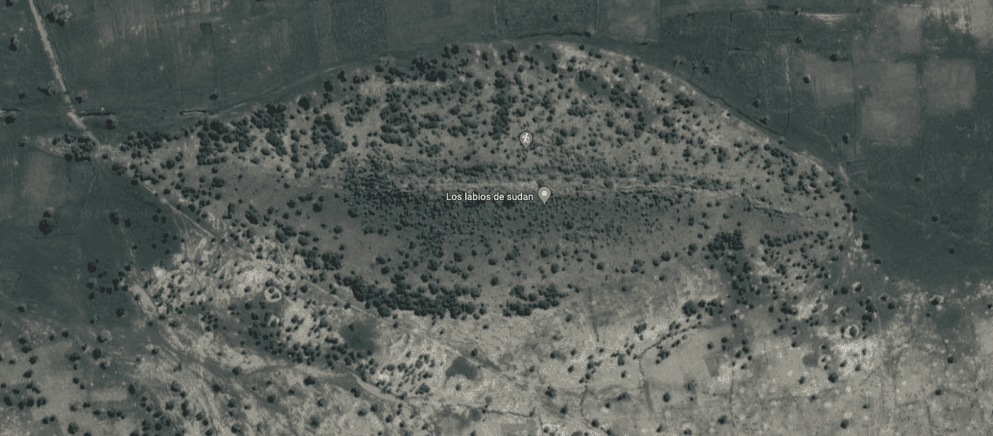
Coordinates: 12° 22′ 13.32″ N, 23° 19′ 20.18″ E
Sudan’s unforgiving desert is known for its harsh beauty, but a strange sight captured on Google Earth reveals a formation that looks suspiciously like a giant pair of lips.
This anomaly has sparked wild theories online, with some even suggesting it’s a portal or some kind of natural anomaly. But the truth is far less mysterious–it’s all about geology playing tricks on our eyes. In fact, the “lips” are actually a natural rock formation where contrasting colors of sand create the illusion.
Sometimes, however, strange sights on Google Earth can have a surprising connection to real-world cultures, as is the case here, since Sudan has a rich history of body art, and lips hold special meaning. For generations, some tribes used lip plates and tattoos to represent status, beauty, or even protection from bad luck.
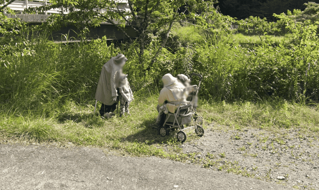
Coordinates: 33.8444° N, 134.1559° E
Nestled in a remote valley in Japan lies Nagoro, once a bustling community, now a village with an ever shrinking population. Today, over 300 life-sized scarecrows, created by a local artist named Tsukimi Ayano, populate Nagoro.
Each scarecrow is carefully crafted, resembling past villagers or imagined characters, styled to look like they are tending gardens, fishing by the river, or even waiting for a bus. They’re so realistic that Google Street View even blurs them sometimes, mistaking them for real people.
That’s how Nagoro has become a “scarecrow village,” attracting visitors from all over. The scarecrows are a way for Ayano to honor the village’s past and keep its spirit alive. In fact, even the closed school is now filled with student scarecrows, a reminder of the children who once learners and played there.
Coordinates: 50° 0′ 38.20″ N, 110° 06′ 48.32″ W
If you’re ever flying over Canada spot a giant head with a headdress, you’ll know you’ve reached the Badlands Guardian, a natural rock formation that looks eerily human-like.
Seeing faces in objects and landscapes is a phenomenon called pareidolia–we often do it with clouds, toast, and even craters on Mars–but when Lynn Hickox first discovered the Guardian in 2005, the internet went wild. What makes it even weirder are what appear to be the “earphones,” which in reality are simply a road and an oil well built much later.
The Guardian isn’t some ancient carving. It’s a trick of light and shadow on the soft rock, making a valley look like a giant face. The name “Badlands Guardian” came from a radio contest, and this natural wonder continues to amaze people around the world.
The area where it’s located is called the badlands, known for its dry, dramatic landscape, carved by wind and rain over thousands of years. Because the location is so remote, most people tend to enjoy the view from Google Earth, though the surrounding area is also really beautiful, and with a rich history thanks to the Siska First Nation people.
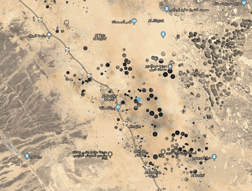
Coordinates: 31.029° N, 37.641° E
Deep in Jordan’s desert lie giant stone wheels, some older than Peru’s famous Nazca Lines. Nicknamed “works of the old men” by locals, these circles with spokes have puzzled scientists for ages.
They were first spotted by airplane pilots in the 1920s, and are best observed from high above, as on the ground they just look like ordinary piles of rocks.
Over 1,000 wheels have been spotted from the air, some as wide as 70 meters, and are mostly found on lava fields. Some are lined up with the winter solstice sunrise or other astrological events, making scientists wonder if they were used for special ceremonies or keeping track of time. Other theories posit whether they might have been used as traps for animals, or even as meeting places for specific rituals.
What’s even more curious is that these wheels aren’t the only mysterious stone shapes in Jordan: there are also giant bullseyes, triangles, and enormous circles–all with yet undiscovered purposes.
Coordinates: 30.0305° S, 115.3565° E
Lost in the Australian desert lies a giant triangle that’s about the size of a football field, with strange lights at each corner. Known as the Outback Triangle, it is located in a remote area known for weird happenings. Planes have even had computer problems flying near it, causing some to think there’s a strange magnetic field messing with things.
Here’s the crazier part: this triangle is almost exactly opposite the Bermuda Triangle on the other side of the world–leading people to theorize that there might be some kind of magnetic connection between the two, messing with navigation everywhere.
And if that wasn’t enough, the area is also rich in Aboriginal history, further blurring the lines between real and make-believe. There’s also a real constellation called the Southern Triangle that looks just like the one on the ground.
Coordinates: 44.244273° N, 7.769737° E
Have you ever seen a giant pink bunny on a mountain? Well, in Colletto Fava, Italy, you used to be able to, back in 2005, when artists decided to create a wild work of art–a 200-foot long stuffed bunny plopped on a mountainside.
This strange sight, called “Hase,” was the brainchild of a group of Austrian artists who created it to look like the bunny fell from the sky, spilling its insides everywhere. It might sound macabre, but it was also meant to be fun–a place for visitors to climb on and explore, like characters in a giant story.
You could even see this giant bunny from Google Earth, and it quickly became a famous landmark. But giant bunnies aren’t meant to last forever, especially on mountains. Sadly, Hase started to rot and fall apart over time. By 2016, it was almost gone. Today, you might only find scraps of pink left, a reminder of this unusual and playful art project.
Coordinates: 72° 00′ 36″ S, 168° 34′ 40″ E
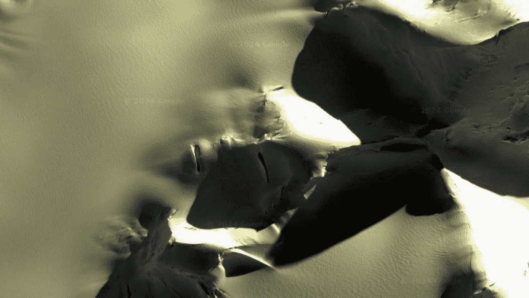
In Antarctica, there’s a spot that looks like a giant, broken human face–another case of pareidolia. Understandably, it’s sparked all sorts of wild ideas, with people saying it looks like everything from a movie villain to a Native American chief.
The “Broken Face” is part of a bigger trend empowered by the availability of Google Earth, making it easier to find weird things on Earth, especially in remote places like Antarctica. Afterall, it is a mysterious place, and that makes some people believe in crazy things, like secret bases hidden under the ice or even giant doors leading underground. People have even spotted what they think is a giant ice ship there, though most of the time, these sightings are just strange rocks or ice formations that look interesting from a certain angle.
Coordinates: 35.524423059378705, -104.57172606840156
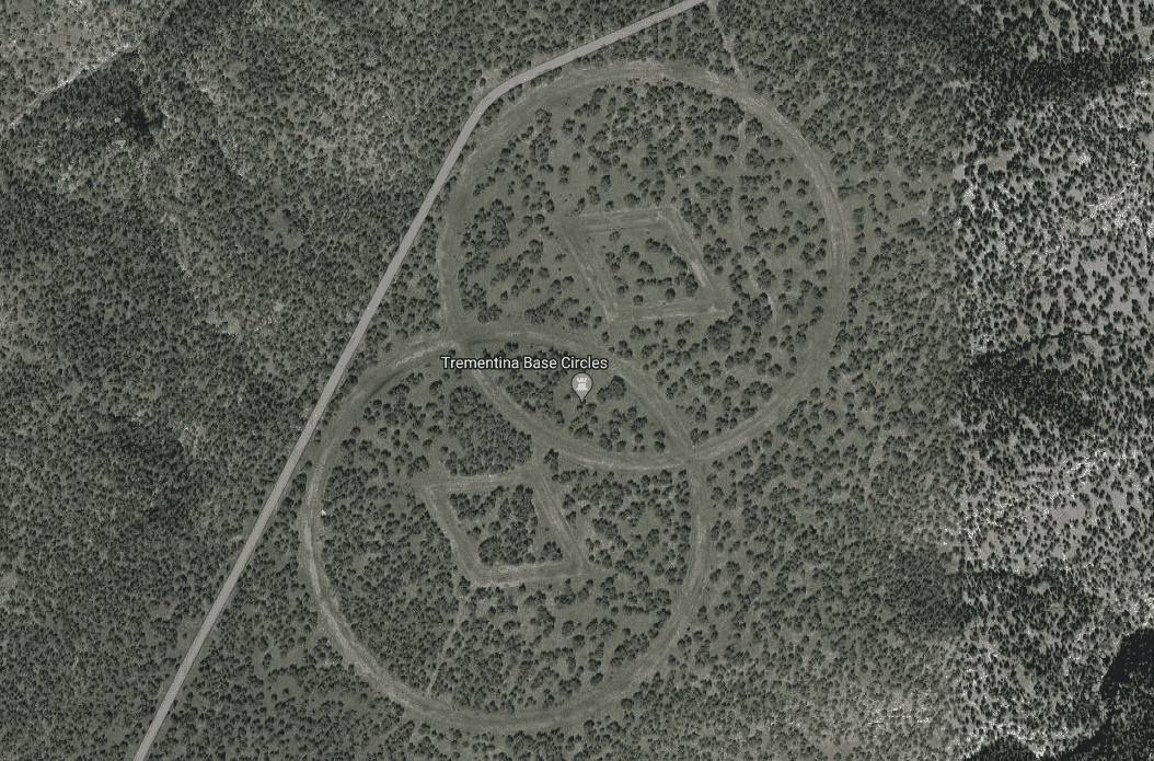
Near Mesa Huerfanita, a lonely spot in the New Mexico desert, lies a place called Trementina Base–built by Scientology, the religion founded by L. Ron Hubbard, to hold onto his writings and recordings forever.
They say it’s an underground maze of tunnels, guarded super tight, to protect Hubbard’s work even from nuclear bombs. The outside is marked by weird symbols allegedly put there to guide Scientologists back from space.
And if that wasn’t enough, the mystery of Trementina Base is also fueled by its proximity to Roswell, famous for UFO sightings, as well as local legends, including stories of evil spirits trapped in caves guarded by cat statues.
Coordinates: 32.676193° N, 117.157661° W
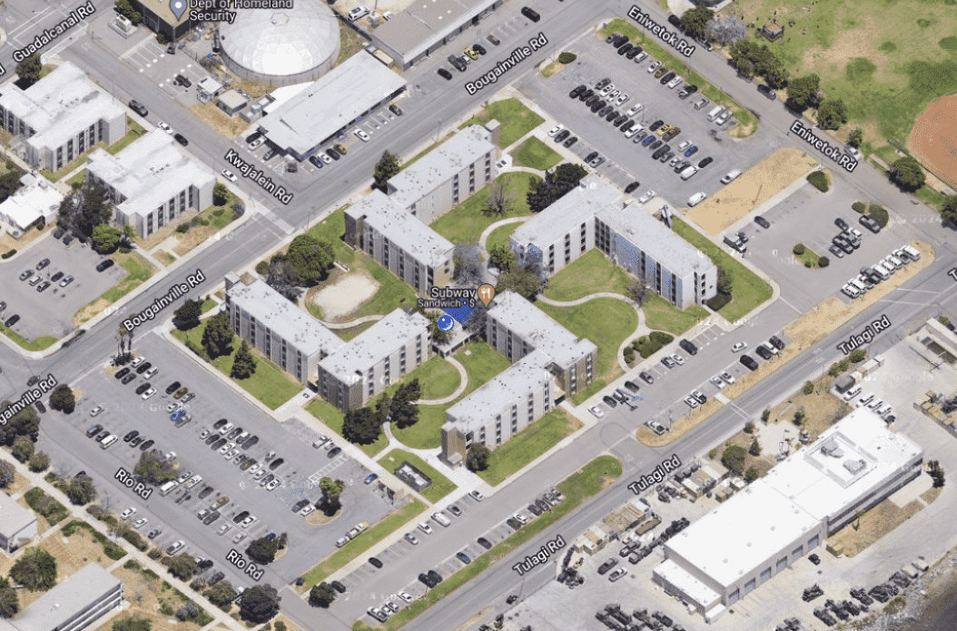
A building complex located inside a San Diego Navy base has been causing righteous controversy because its shape looks like a giant swastika when seen from above.
Designed in the 1960s, the four L-shaped buildings comprising the complex were just meant to be practical, and without any satellite images back then, no one realized they’d form a hate symbol. Fast forward to the invention of Google Earth, and suddenly this major problem was discovered.
As always, theories were abundant: was it a secret Nazi tribute or perhaps a hidden message? The Navy has maintained its position on the shape being a very unfortunate and unforeseen accident, but faced with public outrage, they’ve tried to hide the swastika. They planted trees, built rocks, and even added solar panels, but it wasn’t until recently that the decision came to take a more drastic step and initiate a complete renovation project to turn the swastika into a square.
Not everyone’s happy with the decision, however, with some folks demanding the Navy should tear it all down and start anew. While the debate continues, one thing’s for sure: this building wasn’t planned to be a symbol of hate, but it sure has become one.
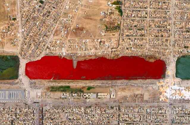
Coordinates: 33.3961° N, 44.4875° E
In 2007, people on Google Earth stumbled upon just such a sight in Iraq. This mysterious lake, nicknamed Blood Lake, sits near Baghdad and is a shocking shade of red.
So, what caused this creepy color? Some blamed nearby factories dumping chemicals, while others thought it might be blood from slaughterhouses. Speculation aside, science offered a different explanation: tiny organisms. In some salty lakes, special algae or bacteria can bloom, turning the water red. This has happened in places like Iran, so it could be the culprit here too.
The weirdest part? The lake’s not red anymore. Over time, the color went back to normal, leaving scientists and armchair detectives alike scratching their heads.
Coordinates: 45.694355° N, 106.948480° E
Have you ever seen a lake so red it looks like something out of a scary movie? That’s the Blood Lake in Mongolia: this bright red lake in the middle of nowhere is seriously creepy, and there are all sorts of wild stories about it.
Its spooky appearance has led some people to say it’s haunted, maybe even a gateway to the underworld. But scientists say it’s something much more explainable–algae and microorganisms in the water that turn it red.
Mongolia is a land of extremes, with vast grasslands, tall mountains, and an overabundance of lakes. Blood Lake definitely stands out from the usual blue and green scenery, making it incredibly unique. With its remote location and creepy color, it’s no wonder people love looking at this lake on Google Earth.
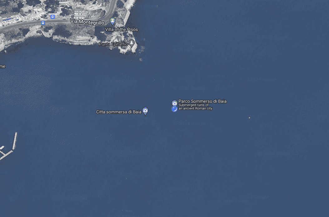
Coordinates: 40.821233140822464, 14.077730718783444
Imagine a luxurious Roman destination where the elite partied in style: that was Baia, a wealthy resort town located near Naples, Italy. Back in the day, emperors like Caesar and Nero vacationed here, enjoying hot springs, beautiful views, and a wild social scene.
But time wasn’t kind to Baia. The ground began to sink because of volcanic activity in the area, causing the Mediterranean sea to progressively swallow Baia whole–turning this once-glorious city into a fascinating underwater archeological park.
And while legend says the town is named after a sailor from Odysseus’s crew, the complex system of tunnels that the city was built upon fueled theories that Baia might be the real-life entrance to the underworld from Greek mythology.
Despite the threat of nearby volcanoes, scientists are working hard to preserve Baia through underwater sensors, protecting the site them for future generations. Today, visitors can explore Baia on glass-bottom boats, snorkeling, and scuba diving, enjoying the sights of ancient statues, mosaics, and other Roman ruins.
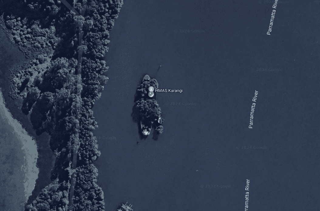
Coordinates:-33.83647313578192, 151.08048915379533
The SS Ayrfield, also known as the “Floating Forest,” lies deep in the heart of Sydney, Australia.This shipwreck is more than a rusty relic, as over time, nature has transformed it into something equally haunting and mesmerizing.
Built in 1911, the SS Ayrfield spent its life hauling cargo up and down Australia’s coast. But by 1972, its working days were over. It was sent to a scrapyard in Homebush Bay–but they never finished the job.
Over time, a vibrant mangrove forest established itself within the rusting hull of the ship, creating a stunning visual contrast and transforming the deteriorating vessel into a floating forest. This natural reclamation has turned the SS Ayrfield into a popular destination for photographers and tourists, providing a unique view of the interaction between human history and nature.
Coordinates: 22.7196° N, 69.5261° E
The Arabian Sea, off the coast of India, is a watery graveyard filled with shipwrecks from different areas of navigation. For centuries, this sea has been a highway for trade, but also a battleground for the weather. Countless ships have met their end here, leaving behind treasures for future explorers.
One famous wreck, Bet Dwarka, tells a story of ancient trade. Archaeologists found Roman pottery and tools, showing this spot was once a bustling hub connecting India to the Roman Empire. Strong currents here protected the ship from decay, but also show how rough the seas could be.
The Arabian Sea wasn’t kind to European sailors either. During colonial times, many ships from the East India Company sank here due to bad weather and sharp coral reefs, taking valuable cargo with them–becoming precious windows into the past for our archaeologists.
Today, thanks to aerial and satellite imaging, archaeologists were able to find Portuguese ships from hundreds of years ago, filled with cannons, building materials, and even ivory–discoveries that help us understand the trade routes and even battles of the past.
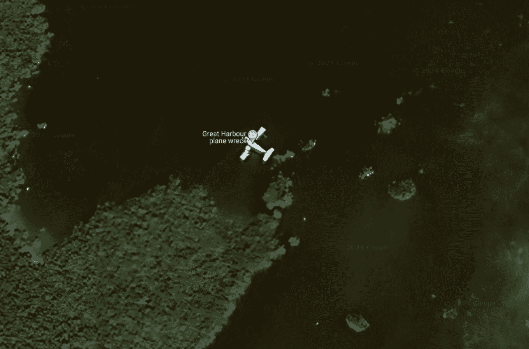
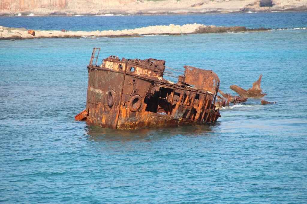
Coordinates: 25.71896620673477, -77.81999522970831
The Bahamas isn’t all just clear blue water and sandy beaches–underneath the waves lies a surprising collection of plane wrecks, each with its own story. These wrecks are a big draw for divers and snorkelers because they’re easy to reach and teeming with colorful fish.
Pablo Escobar’s drug plane is an especially famous wreck–this leftover from the 1980s drug trade crashed in shallow water, leaving behind a giant metal fish haven. Even though it has a dark past, it’s become a popular dive for its easy access and the variety of sea creatures living there.
Another spot, Bimini Island, has a couple of wrecks you can explore. These partially sunken planes create an underwater playground for divers and all sorts of fish. But not all the wrecks are historical–sadly, a plane crash in 2001 took the life of singer Aaliyah. This accident led to stricter flying rules in the Bahamas.
There’s also a wreck near Staniel Cay believed to be from drug smuggling. This shallow-water plane is another popular dive for its easy access and the beautiful fish that call it home.
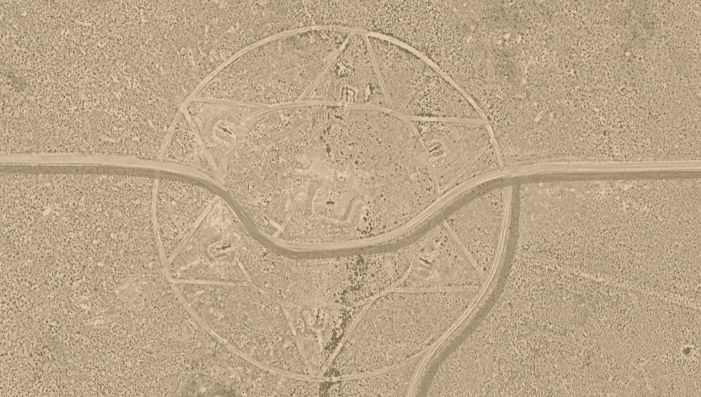
Coordinates: 552.47962028384223, 62.18579069718502
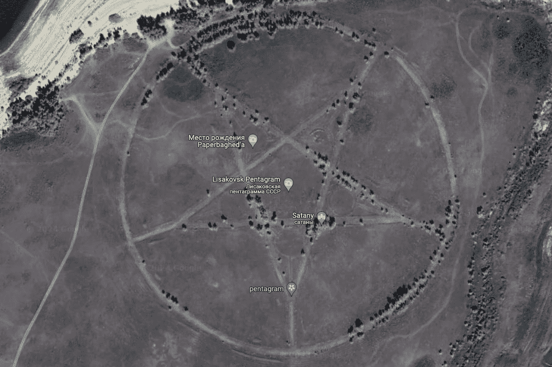
A giant five-pointed star etched into the ground deep in Kazakhstan has sparked wild ideas on Google Earth. As a symbol, pentagrams have a rich history across various cultures and religions, but conspiracy theories have run wild, with some folks thinking it could be a sign of devil worship.
As usual, the explanation is much simpler. This giant star, located near a lake close to the city of Lisakovsk, is actually the remains of an unfinished Soviet-era park. In fact, back when Kazakhstan was still part of the Soviet Union, stars were used on buildings, flags, and even monuments.
Archaeologists believe what happened here followed that tradition. Roads were built to follow the star shape, and though the park was never completed, those roads are still visible from above, making the star stand out even more. Today, the site is abandoned and overgrown, adding to the spooky vibe.
Coordinates: 40.2525° N, 58.4395° E
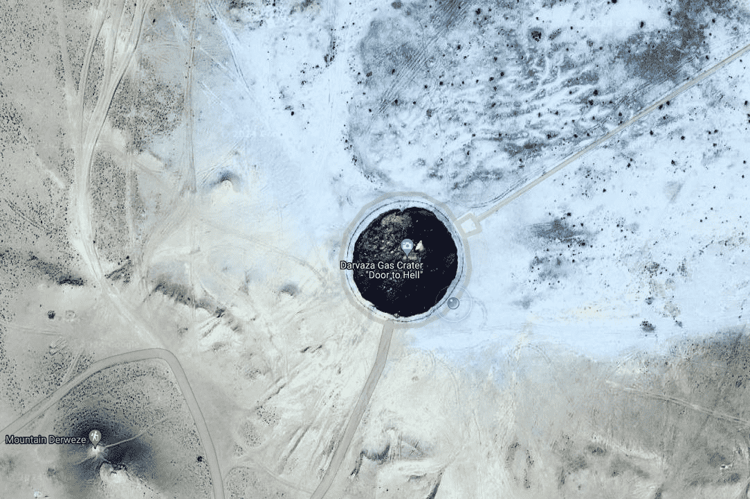
The Darvaza gas crater, also known as the “Gates of Hell,” looks like a giant hole spewing flames in the middle of Turkmenistan’s vast Karakum Desert.
The crater’s fiery history began in the 1980s, though the exact origin story is a bit hazy, with some theories saying Soviet scientists set it alight to burn off escaping natural gas after a drilling accident. Whatever the cause, this fiery pit has become a major tourist attraction, drawing in around 10,000 visitors a year.
At night, the spectacle is truly awe-inspiring. The flames illuminate the night sky, creating an otherworldly atmosphere. While the temperatures can reach up to 1,000 degrees Celsius, the flames burn without any smoke and offer a clear view of the inferno below.
Turkmenistan’s government has considered putting out the fire due to environmental concerns and the waste of valuable natural gas. However, these plans haven’t gone through, and the Gates of Hell continue to burn brightly.
Coordinates: 48.700568° N, 6.189389° E
A strange sight on Google Maps has Nancy, France buzzing. A chilling figure spotted on a balcony has sparked online theories about ghosts and aliens.
The blurry image, nicknamed “Ghost on the Balcony,” shows a tall humanoid figure with glowing eyes. Wild ideas flew online, as they often do, with some convinced it was a supernatural entity. As always, a more likely explanation emerged, positing that the figure was probably just a tiki statue, its unusual shape distorted by the camera angle.
The conspiracy theories got weirder after Google decided to blur the entire scene, leaving people wondering why they would go to such lengths to hide something seemingly harmless.
This case shows how online platforms can turn local oddities into global mysteries. A click and a blur, and suddenly a French balcony becomes a hotbed of speculation.
Coordinates: 19.22° S, 159.93° E
For over 100 years, maps showed a small strip of land called Sandy Island in the Coral Sea, its existence confirmed by eyewitness reports. However, as it later turned out, Sandy Island was what’s called “a phantom island”, a place that never really existed.
It all started in 1876 when a whaling ship spotted what they thought was land. This led to Sandy Island appearing on maps and charts everywhere. Later, even when other ships couldn’t find it, the island remained on maps so it could be avoided during navigation.
It was only in 2012 that a research ship sailed through the spot where Sandy Island was supposed to be and found nothing but deep ocean, leading to the eventual removal of the island from digital maps of the area.
Scientists believe that sailors who swore to have spotted the island might have indeed mistaken pumice, a kind of floating volcanic rock, for land.
Coordinates: 35.7040744° N, 139.5577317° E
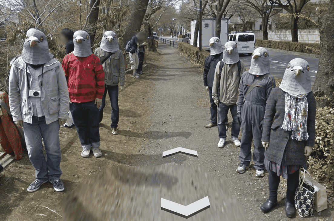
If you’re browsing Google Maps around Tokyo you might just see people in pigeon masks staring back at you. They wear super realistic pigeon masks and pose in a way that follows the Google Street View car, giving unexpecting viewers a real jolt.
These “Pigeon People” are most likely a prank by some creative art students from the art school near the site, known for its offbeat student projects–so it makes sense it might be their doing.
This prank taps into Japan’s love for weird and wonderful art, possibly tapping into the national lore that sees them as lucky and adaptable creatures in old stories. The Pigeon People have gone viral, with people all over the world talking about them on social media. It’s a cool reminder that art can surprise you, even on a virtual walk.
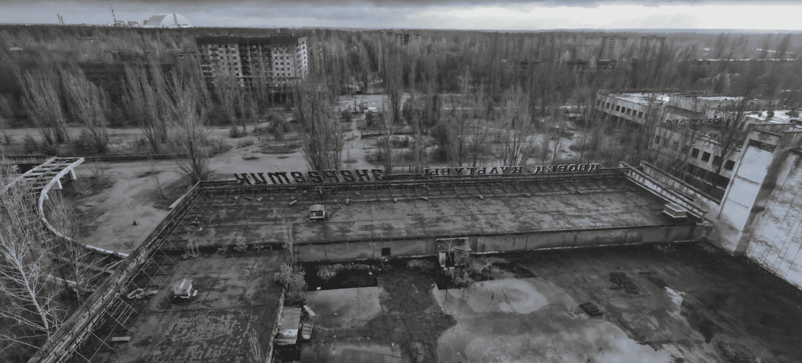
Coordinates: 51.4041° N, 30.0571° E
Deep in Ukraine lies Pripyat, a city forever scarred. Built to house workers for the Chernobyl nuclear plant, it was once a lively place with nearly 50,000 people, but after the disaster in 1986, when a reactor exploded, people fled Pripyat in a single day, never to return.
Today, Pripyat remains abandoned, a haunting reminder of the world’s worst nuclear accident. The Ferris wheel in the amusement park, meant to open just days after the disaster, sits frozen in time. Schools, hospitals, and homes are slowly being reclaimed by nature. With no people around, wildlife is thriving in Pripyat. Elk, wolves, even wild horses now roam the abandoned streets. It’s a strange mix of nature’s beauty and human tragedy.
Today, to keep the radiation contained, a giant steel tomb covers the exploded reactor in Chernobyl, in the hope of protecting people from radiation for the next century.
Coordinates: 22° 18′ 14.15″ N, 114° 11′ 24.66″ E
The Whampoa Boat-Shaped Shopping Centre is a unique landmark that pays homage to the area’s history as a shipbuilding hub. The 360-foot-long mall looks just like a luxury cruise ship–located in Whampoa Garden, the largest private housing estate in Hung Hom, Kowloon.
The area used to be home to the Whampoa Dockyard, one of Asia’s busiest shipyards in the 1800s, with over 4,000 people who once worked there, building some of Hong Kong’s biggest ships. During World War II, the dockyard was bombed by Japan and eventually closed down. In 1985, the area was redeveloped, and the Whampoa Shopping Centre was built into a ship-shaped mall.
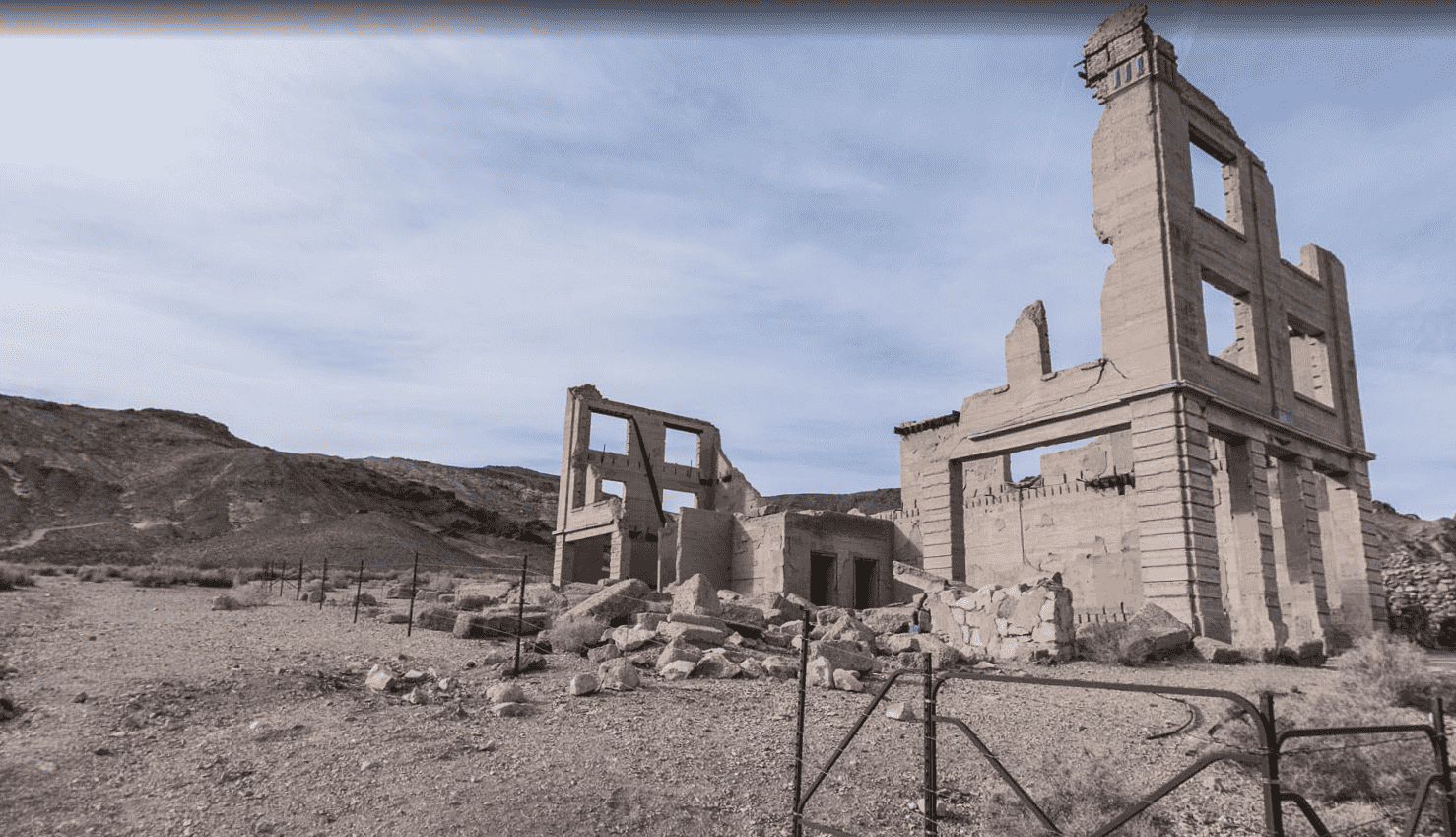
Coordinates: 36.9005° N, 116.8273° W
Rhyolite, Nevada isn’t your average town–it’s a ghost town, a place that boomed then went bust faster than you can say “gold rush.”
Back in 1905, prospectors struck gold in the Bullfrog Hills, and people flooded in like ants to a picnic, leading Rhyolite to sprang up practically overnight. By 1907, it was a full-blown town with electricity, fancy buildings, and even a red light district.
But like most good things, it didn’t last. The gold ran out, and by 1910, Rhyolite was a ghost town with tumbleweeds rolling through the empty streets. Today, Rhyolite is a popular spot for tourists who go to explore the ruins of old buildings, including a cool house built entirely out of bottles.
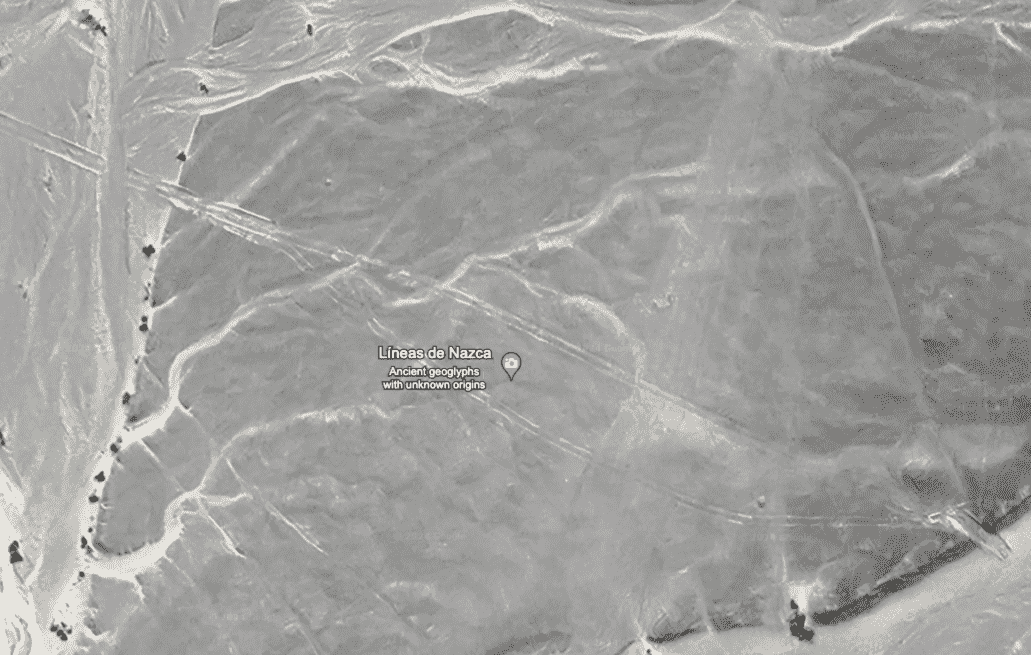
Coordinates: 14.7390° S, 75.1300° W
The Peruvian desert holds a baffling secret: giant etchings scratched into the dry plains, like an enormous ancient etch-a-sketch come to life. These are the Nazca Lines, created by the Nazca culture between 200 BC and 600 CE–massive designs, some as big as a football field, depicting hummingbirds, monkeys, spiders, and strange geometric shapes.
The purpose of these enigmatic artworks remains a head-scratcher for archaeologists. One theory suggests they were a giant calendar, helping people track the stars and seasons. Maria Reiche, who dedicated her life to studying the Nazca Lines, also supported this theory, believing they functioned as a celestial calendar.
Another prominent theory suggests the Nazca Lines were used for religious ceremonies, a line of thought that is supported by the discovery of platforms near some of the figures. The presence of seashell fragments, associated with water rituals, adds weight to this idea, especially considering the desert’s arid climate.
Japanese researchers, using drones and aerial photography, recently identified 168 new designs, including depictions of humans and animals. Preserving these giant etchings is a top priority for Peruvian authorities and international organizations like UNESCO. The dry climate has helped keep them intact for centuries, but threats from urban expansion and mining activities necessitate ongoing conservation efforts. The Nazca Lines are a powerful reminder of a long-lost civilization and a captivating wonder of the ancient world.
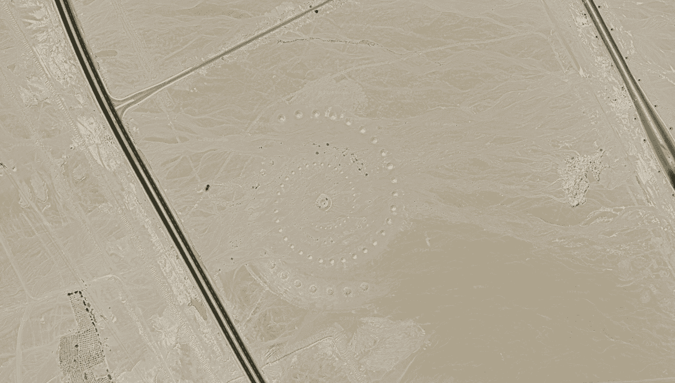
Coordinates: 27.380583° N, 33.631839° E
Imagine a giant artwork carved into the Egyptian desert, so big you can see it from space: this is Desert Breath, a mesmerizing land art project hidden near the Red Sea.
Created in 1997 by 3 Greek artists, Desert Breath is a massive double spiral made of sand. To shape it, they dug out some sand to create pointy mounds, and used that extra sand to build even bigger mounds next to them. The center was meant to feature a pool of water, which has unfortunately dried up.
The intention of the artists who created this piece of land art was to make visitors feel tiny next to the vastness of the desert, while the swirls and points–inspired by the natural shapes of sand dunes–were meant to represent how humans and nature can work together.
Over time, natural erosion has slowly altered Desert Breath’s shape, turning it into a natural, giant clock that tells the story of time passing in the desert. Even though it’s slowly disappearing, Desert Breath is still a popular spot for curious visitors and virtual explorers, especially as some conspiracy theorists try to spin its history into something alien-made.
Fred Metterhausen is a Chicago based computer programmer, and product owner of the current version of Maptive. He has over 15 years of experience developing mapping applications as a freelance developer, including 12 with Maptive. He has seen how thousands of companies have used mapping to optimize various aspects of their workflow.