More than 90% of U.S. online shoppers now expect free two- to three-day shipping, with 86% considering delivery within two days as “fast.” While 41% of shoppers are willing to pay extra for same-day delivery, the pressure on logistics is rising. U.S. business logistics costs hit a record $2.3 trillion in 2022, representing 9.1% of the national GDP—a nearly 20% increase from the year before.
Controlling these costs without compromising speed is a challenge for businesses. This is where route optimization tools come in. With efficient route planning, businesses can cut delivery times, reduce fuel use, and keep costs down—all without sacrificing the customer experience. Best of all, several free tools make it easy to start optimizing routes today.
Table of Contents
HERE WeGo is a free route planner and navigation app that offers a variety of features designed to make travel easier and more convenient.
One of the most useful features of HERE WeGo is its ability to download maps for offline use. This is especially helpful when traveling in areas with limited internet connectivity. Users can download entire cities or regions, and the app will continue to provide directions and other features even without an internet connection.
In 2023, HereWeGo unveiled a fresh new design, emphasizing clearer navigation and ease of use, with features like simple walking directions, public transit information for over 1,900 cities, and turn-by-turn voice guidance for driving, enhancing the overall user experience. Last year’s new features and functionalities included:
In 2024, the company has completed a number of updates:
A couple of improvements and new features that were slotted for 2024 are still in the works:
Here WeGo offers turn-by-turn navigation with voice guidance, making it easy to follow directions while driving, cycling, or walking. It includes pretty accurate traffic information, though it lacks the ability to actively modify an assigned route when the app detects that there is congestion on the way.
Because of this and the limited options it offers for route optimization, users may need to manually adjust their route to achieve the most efficient path.
Pros
Cons
Is This Tool Right for You?
It’s a solid alternative to Google Maps, particularly for users who prioritize privacy.
Available on: PC, Mac, iOS, Android
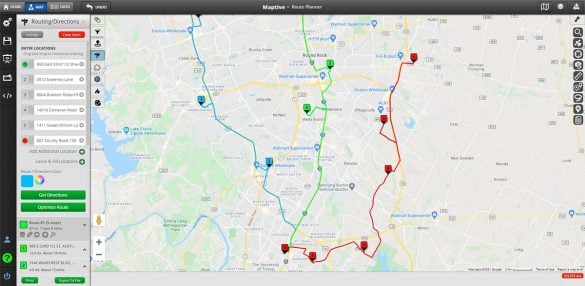
Maptive is the best free route optimizer for professionals of every kind. Maptive offers many advanced options that simpler route optimizers like Google Maps don’t offer, such as:
Maptive offers a free 10-day trial that gives you a chance to try out all of their tools and features for free.
In 2024, Maptive plans to release the version 5 of their mapping software, including:
The new Maptive version will be a complete rebuild from the ground up using OpenGL which will allow for better performance and better data visualization capabilities.
Maptive is easier to use than many tools on this list as it allows you to easily add multiple stops by clicking on the map or by typing in addresses. The Maptive interface is intuitive to use and offers lots of built-in guides.
Pros
Cons
Is This Tool Right for You?
Maptive is perfect for businesses of all sizes that need to optimize delivery routes with multiple stops (think delivery companies, field service technicians).
Available on: Web-based
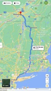
By far, the most common route planner app is Google Maps. Virtually everyone uses this tool to get from one place to another, but not many are aware that it’s capable of planning routes with multiple stops.
Google Maps advertises that they’re able to plan routes with up to ten spots. However, there’s a trick you can use to create routes with up to 25 stops. Google Maps’ user-friendly interface and familiarity make it an excellent choice for a wide range of businesses.
Google is so revolutionary when mapping that many other providers have built their tools using Google’s API. So, it’s clear the company is doing something right when it comes to its mapping tool.
In 2023, Google Maps added a few new features driven by AI integrations, including Immersive View, which can help users plan their trips ahead of time whether driving, walking, or cycling. Immersive view gives users visual turn-by-turn directions and can help avoid getting stuck in congestion thanks to simulated traffic and weather conditions.
So far in 2024, Google Maps has completed several noteworthy updates:
A couple of the new features they announced at CES 2024 are still in the works, including:
The biggest downside of Google Maps is you can’t optimize the order of your stops. Google will calculate your route in the order you enter your stops. For a truly optimized route, you’ll need to list your stops in the most efficient order, which isn’t always easy to figure out.
Pros
Cons
Is This Tool Right for You?
Great general-purpose tool for anyone needing basic navigation with traffic updates (good for personal errands or deliveries with few stops).
Available on: PC, Mac, iOS, Android
If you’re looking for an app with excellent directions and a great user experience, it’s hard to beat Waze. The company was purchased by Google back in 2013, so you might expect it to be reasonably similar to the Maps app. However, Waze offers some innovative features that truly make it unique.
What sets Waze apart is that it collects real-time data from other users. This allows it to provide you with live traffic updates, adjusted routes, and shortcuts. The app also integrates with Spotify, which lets you receive directions while listening to music.
While Waze’s community feature is a nice perk, it’s only effective on routes that other users are traveling. If you’re in a more remote area, you won’t have access to the same amount of real-time data. And if you are on a route with many other users, the number of icons on the screen can block your directions.
Last year, Waze was expected to launch quite a few new features in the near future, including warnings regarding roads with an increased likelihood of accidents, support for Android Auto Coolwalk, and additional toll road controls. In November 2023, Crash History Alerts was indeed launched as its newest safety feature, notifying users of crash-prone roads along their trips.
However, Google–Waze’s parent company–has continued to consolidate the app into its own mapping products and users have noticed that throughout 2023 Waze actually removed some core functionalities, especially across iOS devices.
Although there is increasing overlap, Google assures users that Waze and Google Maps will remain independent apps. So far in 2024, Waze has launched a few updates and new features:
Other features and functionalities that are expected to launch in 2024 include:
The biggest downside of Waze is that you can’t add multiple stops to your route. However, its great directions and fun interface still make it worthy of being included on this list. You can always use it in conjunction with another logistics tool for routes with more than one stop.
Pros
Cons
Is This Tool Right for You?
Ideal for drivers who want real-time traffic updates and crowd-sourced navigation (especially good for deliveries in congested areas).
Available on: PC, Mac, iOS, Android
Not to be outdone by Google, Apple came out with its own mapping app included on all iOS devices. It offers many of the same features as Google Maps but does lag behind in a few areas.
Where it excels is its map design. The maps look great, and they include a 3D view and buildings. Apple users will also appreciate that maps and directions are synced between all Apple devices. So, you can instantly move directions from your iPad to your iPhone.
With the iOS 17 update, Apple Maps added Offline Maps, allowing users to download maps for use when a Wi-Fi or cellular signal is not available, and EV routing improvements, including “the ability to select a preferred charging network when getting directions for your electric vehicle”.
With the release of iOS 18, iPadOS 18, macOS Sequoia, and watchOS 11 in September 2024, Apple Maps has launched several new features:
The biggest downfall of Apple maps is that it only allows you to add two stops. So, busy delivery drivers likely won’t be able to get much use out of this tool. Users have also complained about inaccurate information, which is a big concern for businesses.
The app is only available on Apple devices, so PC and Android users will have to look elsewhere for their route-planning software.
Pros
Cons
Is This Tool Right for You?
Apple Maps is a solid all-around choice for people looking for simple navigation with traffic updates. It’s great for running personal errands or handling deliveries with minimal stops.
Available on: Mac, iOS
TruckRouter is a free route-planning tool designed specifically for the trucking industry. If you’re a trucker, fleet manager, or dispatch professional looking for a solution to meet your needs, this is likely the one.
TruckRouter differs from other route optimization apps because it offers truck-specific routes. Trucks aren’t always able to travel everywhere due to height and weight restrictions, and the tool factors that in when it’s creating its routes.
TruckRouter also alerts drivers to low clearances, provides information on toll roads and costs, and offers a trip cost calculator to estimate your expenses.
The only downside is that the tool is web-based, meaning there aren’t downloadable apps for iOS and Android mobile devices.
Pros
Cons
Is This Tool Right for You?
Specifically designed for truck drivers with features like height clearances and weight restrictions, it is essential for trucking companies and logistics.
Available on: Web-based
SalesRabbit is a lead generation and team management solution for businesses. They also offer a free multi-stop route planner.
This tool features turn-by-turn directions, and multiple stops per route and lets you plot your leads on an interactive map. As you would expect, it works seamlessly with SalesRabbit’s other solutions, so this is ideal for anyone already using their software.
Sales Rabbit’s tool also offers appointment setting services. You can filter your appointments by status, set scheduled reminders, and get directions.
To use this route planner, you’ll need to sign up for Sales Rabbit Lite, which is a free version of their sales management software.
In October 2023, Sales Rabbit announced improvements to Proposals, Scheduler, Importer, and Lead Cards. Proposals now integrates with solar design tools and financing options, Scheduler is in early access and can sync with calendars, and Lead Cards have been improved with multi-disposition tracking, owner display, and a DGAI toggle.
In January SalesRabbit released the Amplify app for SalesRabbit Gamification users, which includes battles, competitions, achievements, social surround activities, and dashboards to boost motivation and productivity.
In April 2024, the latest platform update announced, SalesRabbit underwent significant updates to enhance its functionality for sales managers, representatives, and businesses:
Pros
Cons
Is This Tool Right for You?
SalesRabbit is a tool built specifically for sales teams to plan efficient routes for visiting clients or prospects.
Available on: iOS, Android
Speedy Route is an excellent route optimizer for delivery routes, salespeople, and anyone who needs to plan complicated trips. There are a few features that make Speed Route superior to many other options.
First, it will automatically reorder your stops to create the quickest and most efficient route possible. It also supports timeboxing, which accommodates situations where you can only arrive at a location before or after a specific time.
After your route is calculated, Speedy Route’s drag-and-drop feature makes it easy for you to tweak your stops’ order and make adjustments as needed. Once you’re happy with your route, you can export your directions to a spreadsheet.
While there are many great things about this tool, there are a few negatives. The free version only allows you to enter ten stops, and the interface isn’t as sleek as some of the other options.
Finally, because it’s a web-based solution, they don’t offer any downloadable apps.
Pros
Cons
Is This Tool Right for You?
Tailored to meet the needs of sales teams, SpeedyRoutel is designed for planning efficient routes for visiting clients or prospects.
Available on: Web-based
Circuit provides route optimization software with several advanced features that professionals will love. They offer a free version for those on a tight budget and a paid subscription service ideal for large businesses with more complex needs.
There are many features that make this an excellent tool. First, it allows you to set time constraints on locations if you need to arrive within a certain timeframe. You can also prioritize locations that require you to be there ASAP to ensure they’re first on your route.
Once you set your parameters, Circuit will rearrange your stops based on your parameters to create your optimal route. The app is available on the App Store and Google Play, so you can take your directions with you wherever you go.
You can find all Circuit product updates as they happen in their product update page. So far, in 2024, Circuit has introduced a variety of new features and platform updates:
One of the only downsides to Circuit’s free route planner app is that it only lets you add ten stops which likely won’t be enough for many businesses.
Pros
Cons
Is This Tool Right for You?
Circuit is a great tool for businesses, big or small, seeking to streamline delivery routes with 10 stops or less.
Available on: iOS, Android
Formerly known as Flightmap, Mappr is an impressive online route planner that’s perfect for sales and delivery professionals. What’s unique about this tool is that it optimizes routes based on your vehicle’s size, speed, and volume. This makes it perfect for companies with different vehicle types.
This delivery route planner app is free for up to 200 stops per month per vehicle for two vehicles. While that might seem like a lot, if you’re delivering every business day, it works out to about 18 stops per day split between two vehicles. While not a ton, that’s still more than most apps.
For an extra charge, Mappr integrates with Tookan, a popular delivery management solution. So, if you’re already using that service, this might be a good choice for you.
Mappr also offers a number of sharing options, including exporting to a spreadsheet, sending your map in an email, or using a shareable link.
Pros
Cons
Is This Tool Right for You?
Ideal for delivery services that need to optimize routes with frequent stops and tight delivery windows.
Available on: Web-based
Komoot is a popular route planner and navigation app that’s designed specifically for outdoor activities like hiking, biking, and running.
It allows users to plan their route based on their preferred activity and fitness level and offers a variety of map types, including topographical and satellite maps, that people can use to customize their route based on factors like distance, elevation, and surface type.
Though voice guidance and offline maps are paid features, Komoot’s free version offers turn-by-turn navigation that makes it easy to follow directions while on the go while also giving users access to its large database of popular hiking and biking trails, scenic views, and other outdoor attractions.
And for outdoor enthusiasts who want to plan excursions that go beyond day trips, Komoot also allows users to plan multi-day tours, complete with overnight accommodations and points of interest along the way.
In 2023, Komoot made a lot of updates and released new features that make the app even more powerful and user-friendly:
So far in 2024, Komoot has introduced a number of exciting new features:
Though first-time users will find themselves facing a bit of a learning curve, the app has gained a strong community of users who share their favorite routes, making it easy to discover new places and activities. However, it’s worth noting that users have reported ongoing frustration with Komoot’s routing algorithms occasionally favoring gravel paths over paved roads for road cycling routes, a concern that persists into 2024.
One of Komoot’s particularly useful and community-oriented features includes tracking activity data, including distance, elevation, and speed and can sync with other fitness tracking apps like Garmin, Strava, and Apple Health.
Pros
Cons
Is This Tool Right for You?
Focuses on outdoor navigation, great for cyclists, hikers, and other outdoor enthusiasts.
Available on: PC, Mac, iOS, Android
Free route planning tools are great for small businesses on a budget, but you’ll likely realize that you’ll need a more robust solution once you start to grow.
Here are a few drawbacks of free solutions:
If you have a large fleet that makes many stops per day, these limitations will greatly reduce your efficiency. If you have the budget, we highly recommend looking into an affordable paid tool like Maptive.
Maptive is a mapping software platform that includes a sophisticated route planner and optimizer. It’s built using Google Maps API, which gives you access to their industry-leading technology, along with many additional features that the free Google maps tool doesn’t provide.
Here’s why Maptive is the superior choice for route planning:
Brad Crisp is the CEO at Maptive.com, based in Denver, CO and born in San Francisco, CA. He has extensive experience in Business Mapping, GIS, Data Visualization, Mapping Data Analytics and all forms of software development. His career includes Software Development and Venture Capital dating back to 1998 at businesses like Maptive, GlobalMojo (now Giving Assistant), KPG Ventures, Loopnet, NextCard, and Banking.